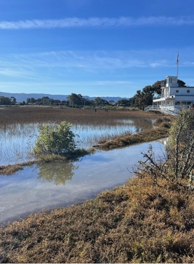
Palo Alto's 1,940-acre Baylands Nature Preserve and the low-lying areas it protects face heightened flood risk this winter after Gov. Gavin Newsom declared a state of emergency on Monday, Sept. 21, ahead of a potentially historic El Niño season.
The National Oceanic and Atmospheric Administration reports a greater than 90% chance of a very strong El Niño event and a 75% chance of a historic one this fall and winter, according to KQED. The California Department of Water Resources has staged 4.4 million sandbags, 400,000 tons of rock and 211 flood material containers at 68 stockpile locations statewide.
The California National Guard has been directed to stand ready for flood response, search-and-rescue and logistics missions. Caltrans will stage traffic-control and road-closure equipment along the highways most at risk.
Laura Hollender, deputy director of the California Department of Water Resources, stressed that Bay Area counties should alert the public as soon as possible because coastal areas may see flooding this winter even without storms, KQED reported. "I think early messaging and early preparation for those communities is going to be really important this year," Hollender said.
Why Palo Alto is watching closely
The Palo Alto Flood Basin, part of the Baylands, helps protect lower Palo Alto and surrounding communities from flooding, according to Santa Clara Valley Water District documents on a nearby tide gate replacement project. A king tide submerged a Baylands trail on Jan. 12, 2024, according to the city's sea level rise planning page.
Climate scientist Daniel Swain of UC Agriculture and Natural Resources told KQED in August that El Niño-driven ocean waves can cause up to 9 inches of additional temporary sea level rise along the coast and San Francisco Bay.
In a worst-case scenario where king tides, storm surge and back-to-back storms all stack together, some areas could see 5 to 6 feet of temporary inundation above historical high tide levels, Swain said.
Mark Merrifield, director of the Scripps Center for Climate Change Impacts and Adaptation, told KQED in August that December king tides could produce "the highest sea levels ever recorded on the California coast." He called it "an unlucky coincidence" that the tidal cycle is also peaking around the end of this year.
The tide gauge near the Golden Gate Bridge was running about 6 inches higher than typical as of August, "partially because of El Niño," said Sean Vitousek, a research oceanographer at the U.S. Geological Survey.
Local defenses and gaps
Local agencies have invested in several flood-protection projects. The San Francisquito Creek Downstream Project, completed in 2019 by the San Francisquito Creek Joint Powers Authority, installed floodwalls and widened the creek to protect 1,700 properties from up to three feet of sea level rise.
The city's Horizontal Levee Pilot Project near Byxbee Park, underway in 2025 and 2026, is the first horizontal levee in the Bay Area connected to San Francisco Bay.
Santa Clara County, partnering with Palo Alto and neighboring cities, received $2.6 million in state SB-1 grant funds in fall 2025 to develop a subregional shoreline adaptation plan. That plan is not expected until 2029.
A 2024 U.S. Army Corps of Engineers feasibility study covering Palo Alto's shoreline found "no federal interest" due to an insufficient cost-to-benefit ratio. The study remains open, according to the city's planning page.
How to prepare
Palo Alto uses AlertSCC, Santa Clara County's emergency alert system, to communicate during emergencies. The city urges residents and commuters to register at oem.santaclaracounty.gov/sign-up-for-alerts. Residents can also subscribe to Nixle alerts and follow the city and Palo Alto Police Department on X for updates.
State leaders have not yet put a price tag on the statewide flood work. No Palo Alto officials had made public statements responding to the Sept. 21 declaration as of Sept. 24.