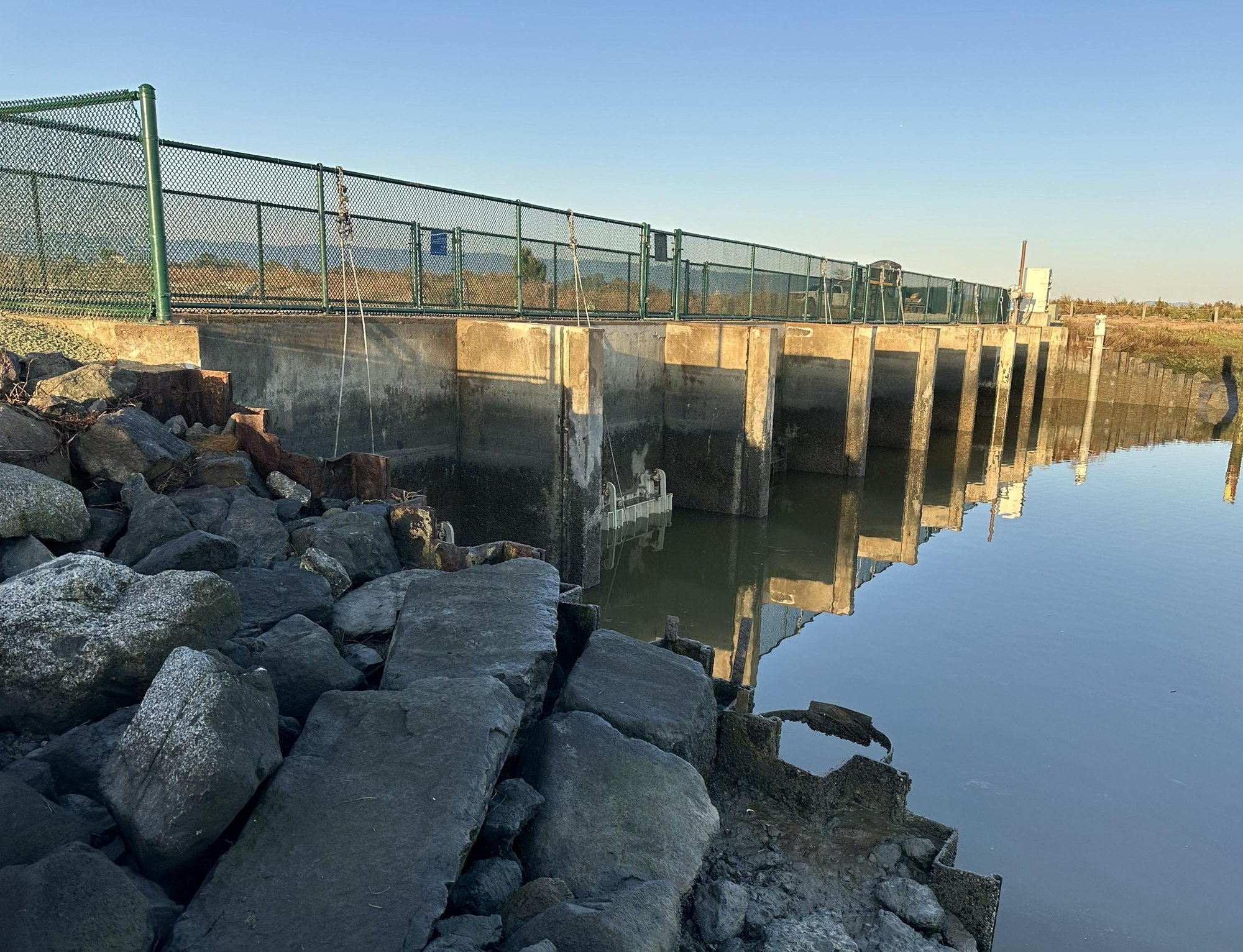
Six aging tide gates that help shield lower Palo Alto from Bay flooding have been replaced, Valley Water announced Friday, Oct. 16.
The upgrades to the Palo Alto Flood Basin tide gate structure come as El Niño strengthens. In its Oct. 8 forecast, the National Weather Service’s Climate Prediction Center put the chance of strong-to-very-strong El Niño conditions through January-March 2027 at greater than 83%. That does not guarantee a wet California winter or any particular storm.
Built in 1957, the tide gate structure sits where the flood basin meets San Francisco Bay, about a half-mile northeast of the Byxbee Park parking lot along the Adobe Creek Loop Trail. The gates block incoming bay water at high tide, then allow water from the creeks to drain when the tide falls.
Stormwater from Matadero, Adobe and Barron creeks collects temporarily inside the levee-ringed, 600-acre basin. Valley Water says this storage helps reduce flooding around homes, businesses, schools and Highway 101.
After decades of saltwater exposure, the structure had cracked concrete, exposed steel and no longer met seismic standards, according to Valley Water. The agency says the rehabilitation will keep the structure in service for at least another 20 years as it works with the U.S. Army Corps of Engineers on replacement plans.
Phase 1, completed in February 2026, installed deep-pile foundations for seismic stability, repaired concrete and added a protective polyester concrete layer to the tide gate deck. Workers also built a new barrier fence for pedestrian and cyclist safety along the trail.
Phase 3, the most recent work, replaced the six tide gates identified during routine inspections. A portion of the Adobe Creek Loop Trail was closed from September 2025 to January 2026 and again from September to October 2026 to accommodate construction. The trail is now fully open.
Phase 2 covers habitat restoration, including three years of plant establishment required by environmental permits. That work is scheduled to continue through early 2029.
Valley Water says it is planning the long-term replacement through the South San Francisco Bay Shoreline Phase II Project, according to its Oct. 16 announcement. The U.S. Army Corps of Engineers-led effort covers shoreline from San Francisquito Creek in Palo Alto to Permanente Creek in Mountain View. A feasibility study for that phase concluded in April 2024, according to Valley Water’s project page.
That study found "no federal interest" in funding Palo Alto's shoreline improvements due to an insufficient cost-to-benefit ratio, though it remains open, according to the city's sea level rise planning page.
As we reported Sept. 24, Gov. Gavin Newsom declared a state of emergency ahead of the El Niño season. Climate scientist Daniel Swain of UC Agriculture and Natural Resources told KQED in August that Kelvin waves associated with El Niño can temporarily raise coastal and Bay water levels by 9 inches or more over days or weeks.
AccuWeather meteorologist Peyton Simmers told Newsweek that El Niño will likely steer frequent storms toward California this winter. "With the frequent storms, it will lead to an increased risk of flooding and heavy rain being above the historical average," Simmers said.
Three of the highest astronomical tides in recorded history are expected to hit California around Thanksgiving, Christmas and the week of Martin Luther King Jr. Day, the Los Angeles Times reported.